
I can say that I’ve observed the summer weather in Western Oregon for more than 40 years- yes i was a geek that far back- and you if you guess my age based on that you will be pleasantly surprised that it all began in elementary school. I grew up in the country southwest of Eugene- there can be some boring times for a youth in summer in the country and a boy naturally turns to the weather. So, I can say I’ve observed many hot summers and few more tepid. So, heatwaves have always been of special interest to me. First, as a geek I am profoundly excited by extremes, second our short heatwaves must have just the right set up to really boil us, and third…it still surprises me that it gets as hot as it does in the Willamette Valley a climate ruled so often by the cool winds of the Pacific with a high latitude. It can get really freakin hot.
The one most dramatic thing about this past summer- and just so you know meteorological summer is June/July/August- was how incredibly normal it was.Temperatures and precipitation really didn’t veer too far off. Here are some facts: We had 14 days above 90ºF- exactly average. Our highest temperature (which occurred three separate times was 100ºF) again precisely our average highest temperature. Rainfall, which we all know dwindles to meager amounts with these months was 1.27″/normal 1.47″ for June. .66″/July normal .65″ and .09″/normal 1.57″ for August- was just about right on the nose. If you thought August was dry you were correct but it did not even fall into the 10 driest on record. It may just be that it culminated with that late heatwave the third week of the month. 99º, 100º, 100ºF in a row sucked what little moisture was left from the surface and deeper soil horizons. .
Remember that we just came off one of the warmest winters of all time- for averages the warmest and a really warm and dry spring. This past summer could have just followed the pattern that we’ve come to recognize as up, up, up. (Last summer was technically the hottest ever with a record 29 days above 90ºF, a record number of days above 80ºF and the most overnight lows above 60ºF.) But the climate is made up of averages and as I’ve shown those for summer 2016 were well, average. Now just in time for your freaky Fox News loving, touched in the head, climate denier relative to chime in and remark that the numbers have been skewed to keep those greedy climatologists rolling in the dough. well, no they haven’t. The numbers which are dutifully recorded every six hours are right where everyone can see them on the Portland NOAA website. No one is hiding anything from anyone. Thats just bullshit. Thank you world wide web from the geekiest part of my heart.
But our gardens? What about our gardens? One of the things that mostly bamboozles me about our climate is how little people, even the weather service seems confused that we have wet summers? Even they are forever talking about rain chances in the future. But as long as I’ve been an Oregonian our summers have been dry. Bone dry. See above for our three summer month averages. They add up to exactly 3.69″ for three months. Thats EXACTLY what we average for the entire MONTH of October. Yep EXACTLY. Add high sun angle, repetitive bouts of hot weather sucking away soil moisture and you have one arid scene. In addition to that if you are an avid or even meek gardener you know that certain things can’t happen in our climate without some juicy intervention. And if some forgetful person decides to challenge me then I simply tell them to plant a vegetable garden in May and then NEVER water it. This isn’t the muggy, summer rainfall eastern United States- you know how that veggie plot would fare. (Don’t get me started on planting trees in May-July without follow up irrigation, the attrition rate is horrendous).
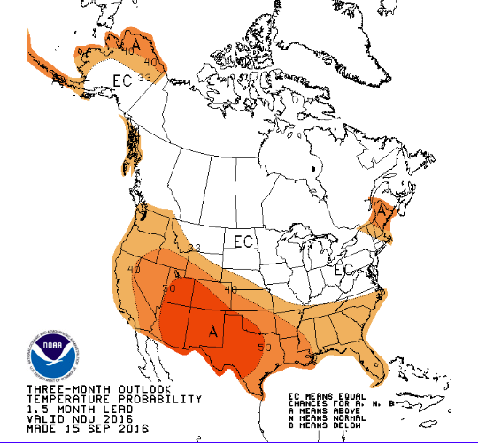
Fall to early winter is forcecast to have above normal chances of average temperatures. The above map is for November/December/January- Courtesy PDX NOAA
As an aside you wonder why we have so many lush native trees? Well a good deal of them are actually summer drought tolerant. In fact a winter wet summer dry environment actually favors conifers which is one reason why they dominate the PNW. They are by and large much more efficient at preventing moisture loss. And trees that are planted and become established have roots that follow the sinking subsoil moisture of the drying surface soil of spring into summer. The roots can reach far down- as far down and wide as the dimensions of the canopy above ground. The rain that falls onto the soil for the rest of the wet year sinks deeper and deeper and the roots of trees follow.
Now that we’ve recapped summer lets look at the future. You have to know that we are not headed for another El Nino or even a La Nina, nope 2016/17 will be a winter of No Nino. And that can mean several important things. First for the most part predictions favor a normal climate regime for our region in the coming months. And if you thought the last two winters were abnormally warm you were correct. Don’t expect that this winter- there are slightly elevated chances of an arctic outbreak in a No Nino- and it has provided some of our coldest episodes-And as the recent past has been mild a normal winter would average 2 days below 20ºF, personally we could and I say COULD experience our coldest weather since December 2013. I’m not just making that up. The averages point us in that direction. On average we get an arctic outbreak, a Phormium killer, an Agave melter once every three years. So you do the math. And as gardeners we should be nothing if not prepared.
So a normal winter is a distinct possibility but this year there is wrench in the forecast story. What 18 months ago was deemed ‘The Blob’ was an abnormally warm region of sea surface temperatures in the north Pacific. It had a profound effect on last summers scorching temperatures. It dissipated for quite a few months but then voila’ its back-as of late this summer. This could have a pronounced affect on our winter weather, what that is remains to be seen. Its not widely reported, but I’ve heard whispers that this isn’t actually a manifestation of global warming but more likely a shift in what is known as the Pacific Decadal Oscillation. Thats when every 10+ years or so the Pacific Ocean pulls a switch and warm water collects to the north and cooler water goes elsewhere (South), think of it as a much much longer duration El Nino event but instead of warm water flowing east and collecting against South America, it moves north and gets caught in the North Pacific. This could do several things, it could re-orient the jet stream, it could funnel immense amounts of moisture to our doorstep, it could modify our temperatures or it could move to the west causing the jet stream to plunge north to south. We’ll just have to wait and see.
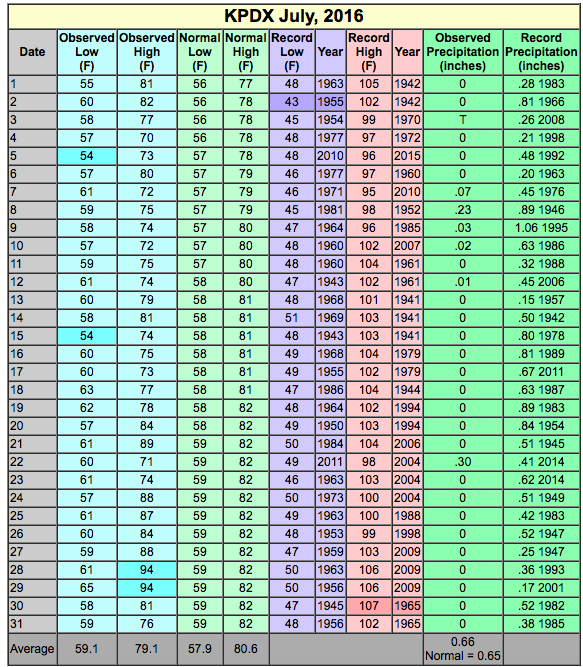
July 2016 Climate Report-
Link to the current climate report. PDX NOAA http://www.wrh.noaa.gov/climate/temp_graphs.php?wfo=pqr
So far NOAA hasn’t mentioned the Blob redux. Instead they show a very straight line right down the climatological center. Which jives perfectly with a No Nino year. If you would like to do your own climate research, I encourage you. All the information is right there on the ‘Climate Portal’ of the NOAA Wesite. If you don’t like numbers they even carefully color code the highest and lowest temperatures of the month. There you can find daily temperature records for select sites around western Oregon as well as temperature normals and rainfall records. Its not only handy for geeks its a great way for gardeners to either figure whats what or to compare the records in your own backyard. Here’s to a happy fall.
